The route of the Exodus is primarily a geographical problem, not an archaeological problem.
The mission of AncientExodus.com is to explain Exodus locations and enigmas using sound geographical research.
Where was Mount Sinai? What was the route of the Exodus? Is Jabal al-Maqla Mount Sinai?
These questions and more are answered in the new book:
The Exodus Mysteries: of Midian, Sinai & Jabal al-Lawz.
The location of the Exodus sea crossing, and the route needed to reach it, are explained in–
The Lost Sea of the Exodus:
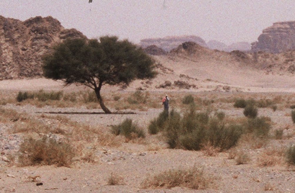
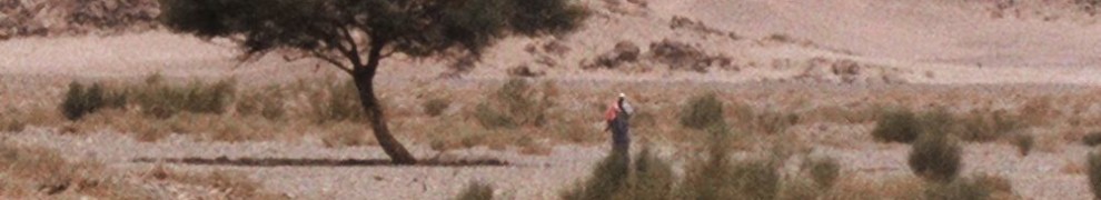
Wadi ar-Rayt–the southern route leading to Jabal al-Maqla, a likely candidate for Mount Sinai. (Jabal al-Maqla means “mountain of the quarry” in Arabic).
The author took the above photo in northwest Saudi Arabia, in a desolate part of Wadi Rayt, about 50 km (32 mi.) southeast of Jabal Maqla, a peak in the Jabal al Lawz range that has been named as a possible site for Mount Sinai. If such is the case, this area would be part of the biblical Wilderness of Sinai, which lies in the region called Horeb (meaning parched or dry in Hebrew).
If you look closely, there is a lone man near a large acacia tree. The temperature was near 100 degrees. We stopped to ask if he needed help. He looked to be about 70 years old and had no water. He calmly explained that he was an Ethiopian. His destination was about five miles away, and he said that he didn’t need any help. We gave him a liter of water and bid him farewell.
The Major Geographical Questions of the Exodus
The popular curiosities include the locations of Mount Sinai, the sea that parted (Red Sea), Kadesh (or Kadeshbarnea) at the foot of the Promised Land (Canaan), Mount Hor (the mountain at which Moses’ brother Aaron was buried), and the rocks that miraculously gave water.
For almost 2000 years, tradition has held that Mount Sinai was one of several peaks in the southern Sinai peninsula (see Figure 1). However, in the last century, and particularly in the last 30 years, attention has turned to northwest Saudi Arabia, the ancient location of the land of Midian (right side of Figure 1). Moses spent 40 years in exile in Midian, during which time, he visited the “Mountain of God” (Exodus 3:1), later called Mount Sinai. In this general region, the lofty Jabal al Lawz mountain range has been proposed as the possible location for Mount Sinai. The range lies about 30 miles inland from the Gulf of Aqaba.
The sea of the Exodus, which Bible translations call the “Red Sea,” has traditionally been linked with the Gulf of Suez near Egypt. In the Hebrew Bible, the name for this sea is Yam Suph. However, beginning in the late 1800s, some Egyptologists have argued that Yam Suph was really a “Sea of Reeds” or “Reed Sea,” located on the eastern fringe of the Nile Delta. The map in Figure 1 illustrates one version of this theory. More recently, the case has been made that Yam Suph referred solely to the Gulf of Aqaba, which separates the Sinai Peninsula from Saudi Arabia (see The Lost Sea of the Exodus, 2nd Edition).
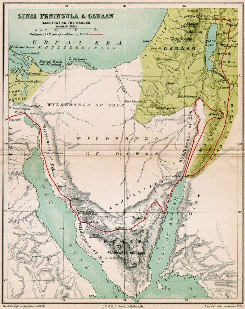
Figure 1. A Traditional Exodus Route Map. Mount Sinai is (incorrectly) shown in the southern Sinai Peninsula. The sea crossing is (incorrectly) depicted at an inland “Reed Sea” in eastern Egypt. Mount Hor is (incorrectly) shown in Petra. Click map to enlarge.
The Hebrews reached Mount Sinai two months after leaving Egypt and then spent 11 months and 5 days there. They reached Kadesh or Kadesh-barnea in the early summer of the second year of their journey. It was located in the northern part of the modern Negev (Negeb) desert of Israel, on the southern border of the Land of Canaan. After the Hebrews failed to begin their conquest of Canaan, that generation was sentenced to spend the next 38 years in, and around Kadesh, (Deut. 1:46) and in the Aravah (Arabah) valley that runs between the Dead Sea and the Gulf of Aqaba of the (Figure 2).
Investigations in the late 19th and early 20th century popularized a location for Kadesh at Ain Qadeis (Ain Kadis) on the crude basis of a linguistic similarity. Ain Qadeis is in the Egyptian Sinai, just west of the Negev border of modern Israel (Figure 2). However, a more likely location is in the watershed of Nakhal Zin or Wadi Fikreh, which extends to the southwest below the Dead Sea (Figure 2). Aaron died on the top of Mount Hor near Kadesh. Arab tradition places Mount Hor at Petra in modern Jordan, which was the land of Edom in the Exodus. But, this idea clashes with scripture, which forbid the Hebrews to trespass the land of Edom (Exod. 20:14-22).
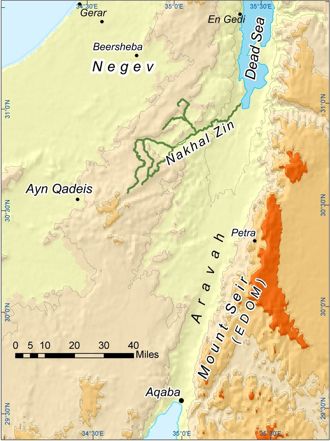
Figure 2. Possible Locations for Kadesh or Kadeshbarnea. The traditional location is at Ain Qadeis. The more likely location is in the southwestern Nakhal Zin watershed.
The first rock that gave water for the thirsting Hebrews was in Horeb, the name of the region that hosted Mount Sinai. The event occurred in the second month of the Exodus, just before reaching the Wilderness of Sinai (Exodus 17:6). The second rock that gave water was at Kadesh (Numbers 20:8) at the beginning of the 40th year of the journey (Numbers 20:1). The Bible uses two different Hebrew names for these rocks, tzur and selah. The Hebrew meaning of tzur suggests a hard rock (e.g., igneous), while that of sela suggests a soft rock (e.g., sedimentary). These terms indeed agree with the geology of their respective regions.
One pressing non-geographical question concerns the dating of the Exodus. The biblical date, calculated from the building of Solomon’s temple in Jerusalem (I Kings 6:1), suggests about 1446 B.C. However, this time frame does not mesh well with the traditional dating of the Egyptian dynasties. Hence, Exodus evidence has been found in Egyptian dynasties (e.g., 12 and 13) whose assigned dates are much older than 1446 BC. Other popular questions involve the size of the Hebrew multitude, which has been estimated to range from a few thousand to several million, and their ability to survive in such an arid region for forty years.
Again, AncientExodus.com is dedicated to explaining such issues using sound research practices. Please ENJOY!