In his ca. AD 50 letter to the Galatians, the Apostle Paul (AD 5 to 62-64) made a curious reference to the location of Mount Sinai. In the verses of interest, Paul used an allegory to contrast the outworking of the Mosaic Law versus the divine grace of the New Covenant:
Now this is an allegory: these women are two covenants. One is from Mount Sinai, bearing children for slavery; she is Hagar. Now Hagar is Mount Sinai in Arabia; she corresponds to the present Jerusalem, for she is in slavery with her children. But the Jerusalem above is free, and she is our mother (Gal. 4:24-26 RSV, my underlining).
Here are the key lines as rendered in the KJV:
For this Agar [Hagar] is mount Sinai in Arabia, and answereth to Jerusalem which now is, and is in bondage with her children. But Jerusalem which is above is free, which is the mother of us all (Gal. 4:25-26 KJV, my underlining)
This text can easily be glossed over as merely a spiritual lesson. However, it employs wordplay using two Greek geographical terms (emphasized above) to seemingly identify the location of Mount Sinai relative to Jerusalem. If this underlying geographical relationship was fictitious, the allegory would be hollow, and the wordplay would fall flat.
In this text, Abraham’s concubine, Hagar, who bore his child by a human scheme, was symbolically linked with Mount Sinai, where Moses received the law (Torah). Hagar’s offspring, instead of living free in the Promised Land (e.g., Jerusalem), were pictured as being spiritually mired at Sinai in legalistic bondage to that law. Conversely, Abraham’s wife, Sarah, bore his child by a divine plan. Her “offspring,” born of grace, occupy a superior Jerusalem where they live free of bondage.
In constructing this allegory, Paul used a real-world geographical relationship as the backbone of his spiritual illustration. Here is the core geographical content:
…Mount Sinai in Arabia…answereth to Jerusalem…which is above….
Paul’s matter-of-fact mention of “Mount Sinai in Arabia” indicates an awareness of the mountain’s location. If Church Historian Eusebius, three centuries later, could give a detailed description of the location of Midian and Mount Sinai, one must assume that Paul possessed that knowledge, especially considering his education and religious training.
Paul is credited with authoring 14 of the 27 New Testament epistles. He was the son of a Pharisee (Acts 23:6), was taught by the respected Gamaliel (Acts 22:3, 5:34), and became a high-ranking Pharisee (Acts 26:5). He spent a three-year sabbatical in some part of Arabia (Gal. 1:17), which may have given him additional geographical insight.
Paul’s Definition of Arabia
Not knowing Paul’s definition of Arabia only presents a small challenge. Was it on both sides of the Gulf of Aqaba? Did it refer only to the Arabian Peninsula? Did it include part of the Sinai Peninsula? His definition can only be estimated based on: (1) the Old Testament definition of Arabia, and/or (2) the secular geography existing ca. AD 50.
The Old Testament Arabia
Based on the Old Testament (OT) mentions of Arabia, Paul would have associated it with the Arabia Felix east of the Red Sea, cited by his near-contemporaries Josephus and Ptolemy. An antique map of Arabia Felix based on Ptolemy is shown in Figure 1. Midian explorer Richard Burton explained that Arabia Felix was “…the land extending south of El-‘Akabah [Aqaba]… a vague term referring especially to Midian and containing the remainder of the Peninsula” (1979, 137).
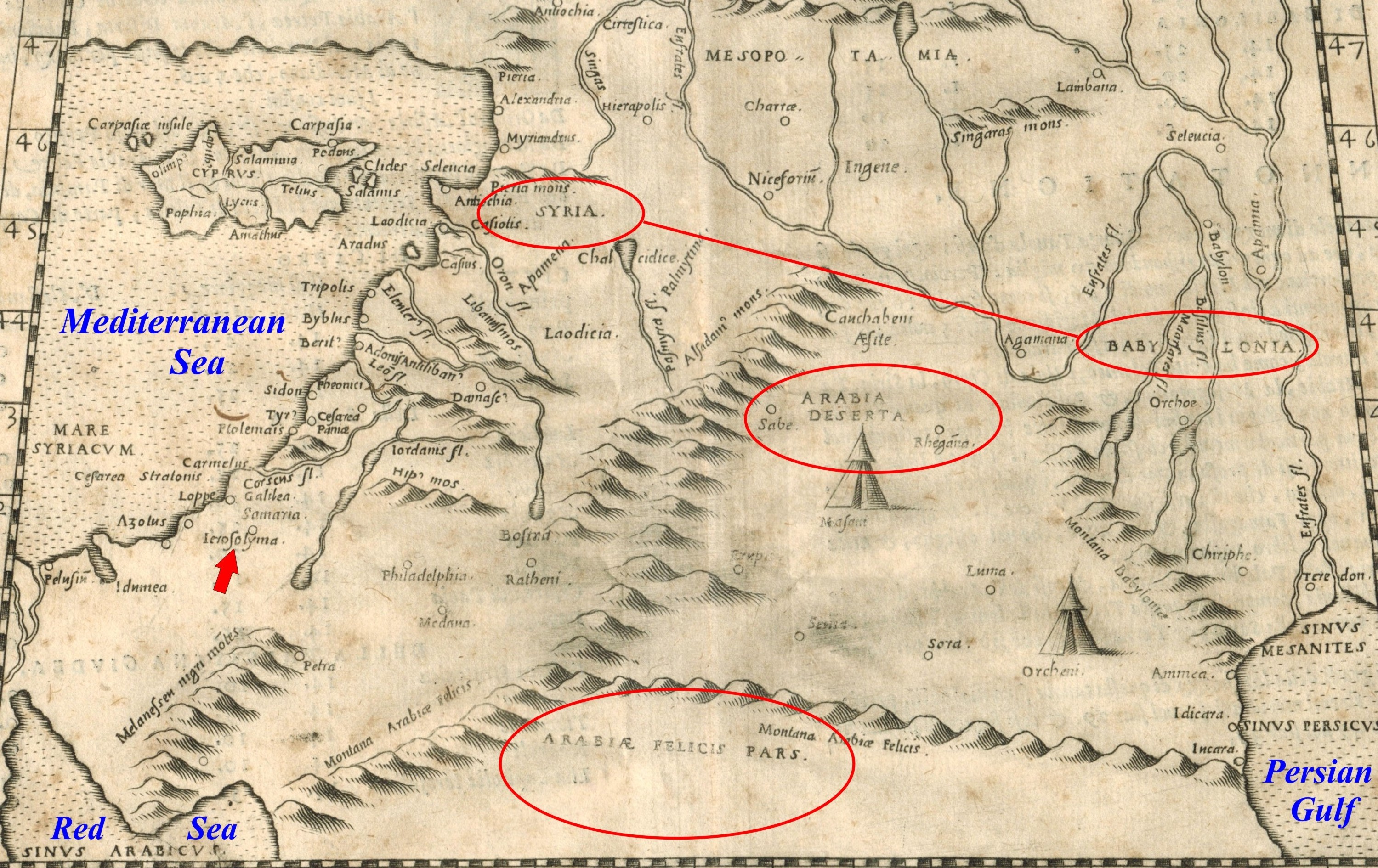
Figure 1. A Map Based on Ptolemy Showing Northern Arabia. Strabo stated that “the whole of Arabia” lay south of a line between Syria and Babylonia (drawn in red). Arabia Felix was still farther south, bounded by the Persian and Arabian Gulfs. Arabia Deserta is shown below the Syria-Babylonia line. The future “Sinai Peninsula” is shown directly south of Jerusalem (arrow), but it should be placed farther west. No Arabia Petraea region is shown. From Ziletti 1574, Venice. (author’s collection)
A key OT reference to Arabia concerned the bounty that Solomon received from the queen of Sheba, described as: “…revenues from merchants and traders and from all the Arabian kings and the governors of the territories” (1 Kin. 10:15). Sheba was linked with Saba, the most important of the south Arabian kingdoms, whose capital was at Marib from 1200 BC-AD 275 (Kitchen 1994, 110). Sheba is also mentioned in the Qur’an (sura 27:20-44). Islamic scholars place the kingdom of Sheba in south Arabia.
In the 8th century BC, Isaiah cited Dedan, (known to have been in Arabia Felix): “a prophecy against Arabia: You caravans of Dedanites, who camp in the thickets of Arabia….” (21:13). It was also mentioned in the 6th century BC in Jer. 25:23-24, “Dedan, and Tema, and Buz, and all that are in the utmost corners, and all the kings of Arabia, and all the kings of the mingled people that dwell in the desert.”
Also in the 6th century BC, Ezekiel’s lament named Arabia in conjunction with Dedan, Kedar, and Sheba (27:20-22). Kedar, who was a son of Ishmael (Gen. 25:13), gave rise to an Arabian tribe (Gesenius 1979, 6938).
Existing Historical Accounts of Arabia
The main problem with the extra-biblical references to Arabia existing at the time of Paul is that they do not necessarily discriminate between locations east or west of the Gulf of Aqaba.
Circa 440 BC, 500 years before Paul, Herodotus’ general description of Arabia referred to the modern Arabian Peninsula, extending from the Persian Gulf, westward to the Arabian Gulf (1980, 283). Herodotus also noted that Arabia was a neighbor to Egypt (ibid. 133) and hosted the Arabian Gulf, which ended near Egypt (ibid. 132). His statements did not clarify whether what is now called the Sinai Peninsula was within this Arabia.
Strabo (fl. 64-63 BC-AD 24) explained that “the whole of Arabia” lay south of a line between Judaea/Syria and Babylonia (Strabo 1966, 16.3.1). Arabia Felix was still farther south, bounded by the Persian Gulf on the east and the Arabian Gulf on the west (ibid.); paralleling the modern Arabian Peninsula description. The map in Figure 1 illustrates these concepts.
Strabo seemingly considered the Sinai Peninsula region to have been part of Egypt, not Arabia, based on his statement that Syria was “…bounded…on the south by Arabia Felix and Aegypt” (ibid. 16.2.1). However, this possibility clashed with his later observation that “the country between the Nile and the Arabian Gulf is Arabia” (ibid. 17.1.21).
His citation of Eratosthenes indicated that a northern segment of Arabia lay between Judea and Arabia Felix: “…concerning the northerly, or desert, part of Arabia, which lies between Arabia Felix and Coele-Syria and Judaea, extending as far as the recess of the Arabian Gulf…” (ibid. 16.4.2, my underling). If this “recess” was the Gulf of Aqaba, then this segment of Arabia did not extend west as far as the Sinai Peninsula.
This territory would correspond with the later Roman Province of Arabia, which was part of Arabia Petraea. The antique map in Figure 2 shows Arabia Petraea as “Arabia Petree.” However, this province did not yet exist in the time of Paul.
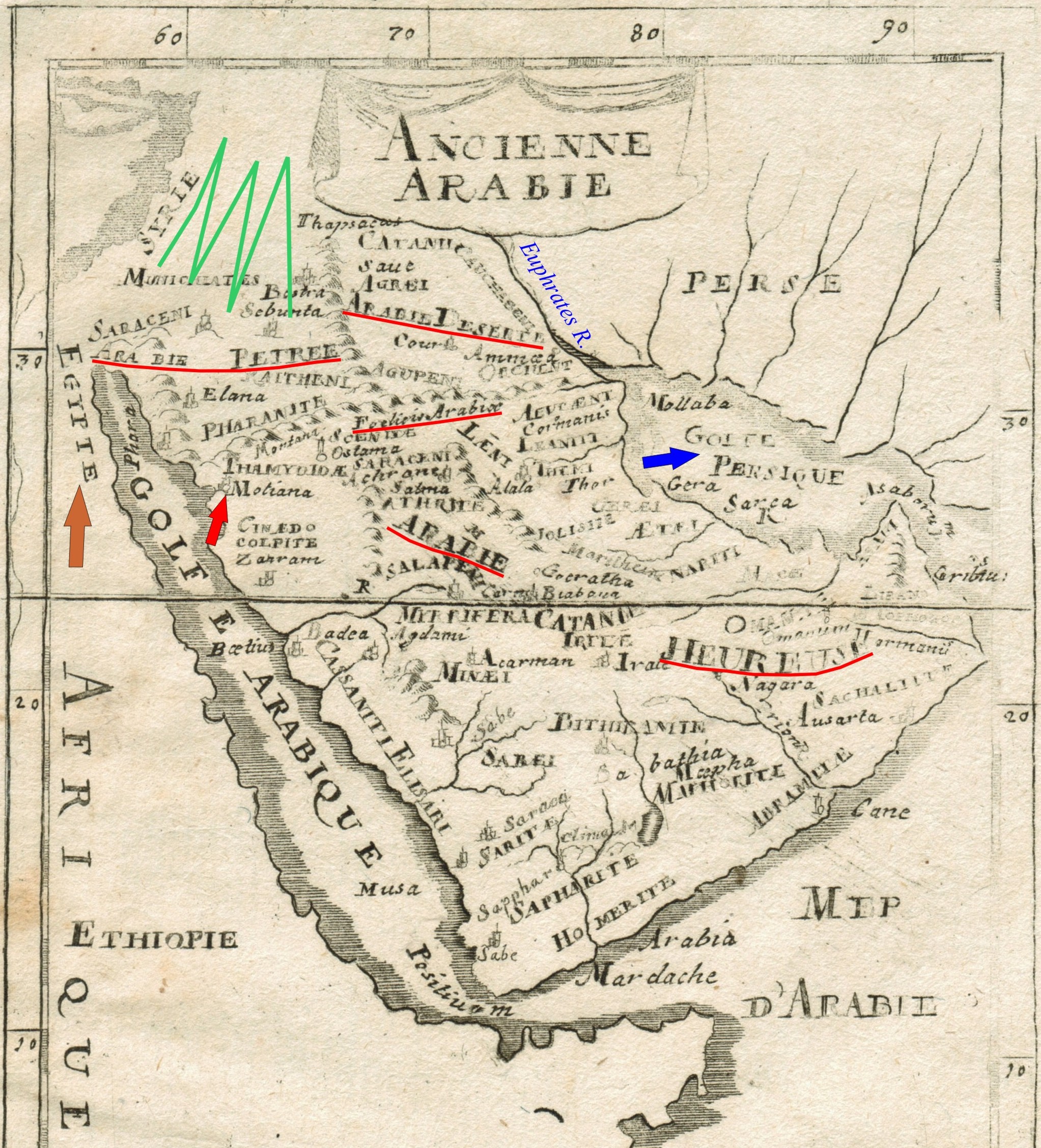
Figure 2 Circa 1719 Map of Arabia. Arabia Deserta lay between Syria (green) and the Euphrates River. “Foelicia” Arabia (Arabia Felix) or “Arabie Heureuse” (French: happy), occupied the Arabian Peninsula. “Arabie Petree,” sandwiched between southern Syria (Judea) and Arabia Felix, is shown extending west to Egypt (brown arrow). “Motiana” (red arrow) is Ptolemy’s Modiana, a part of Midian (Section 4.2). (from Allain Manesson-Mallet 1719, author’s collection)
A generation after Strabo, Josephus (fl. AD 37-100) referred to this northern Arabia as “…a country that borders upon Judea.” (Josephus 1960, 290, Ant. 14.1.4), which he associated with the Nabataeans and Petra (ibid. 36, Ant. 1.12.4; 89, Ant. 4.4.7; 94, Ant. 4.7.1). This region did not include the Sinai Peninsula in Josephus’ day. However, Josephus specifically cited Arabia Felix as the location of the offspring of Abraham’s wife Keturah, which included Midian (ibid. 38, Ant. 1.15.1).
Conclusions about Paul’s Arabia
In these secular accounts, Arabia generically pertained to a widespread region, extending from the Persian Gulf westward to Egypt. The historical lack of specificity was partially due to the lack of distinction between the Sinai Peninsula and the Arabian Peninsula. This imprecision was a product of the geographical obscurity of the Gulf of Aqaba, whose true size and position were not known, as illustrated in many early maps, including Figures 1 and 2. Arabia Felix is an exception as it was known to lie east of the Gulf of Aqaba and Red Sea.
Hence, if these secular Arabia definitions are broadly applied to Paul’s text, it is impossible to determine whether his Mount Sinai was east or west of the Gulf of Aqaba. Paul’s Arabia also cannot refer to the Roman Provincia Arabia or Arabia Petraea because these entities had not yet emerged.
If Paul’s Arabia was based on Old Testament references, then Mount Sinai would likely lie in Arabia Felix. Under these circumstances, the only certain conclusion is that Paul’s “mount Sinai in Arabia” pertained to a place somewhere south of Judea.
Galatians’ Clues Concerning Mount Sinai
Fortunately, Gal. 4:25-26 provides other helpful clues. Corresponds or answereth are translated from the Greek sustoicheo, which means “corresponding,” as in soldiers filing together in ranks (Strong 1990, #4960). Aristotle used “sustoichos” in the geographical sense of standing on the same row or coordinate (Liddell and Scott 2000, 783). He also used sustoichia, meaning of “a coordinate series” (ibid.). Hence, this word generally described a linear spatial relationship. In modern terminology, we might say that Jerusalem and Mount Sinai were on the same parallel of latitude or meridian of longitude.
In my opinion, Paul used sustoicheo as a way to grid the location of Mount Sinai relative to Jerusalem. The use of sustoicheo in Galatians 4:25 is especially significant in that it is not found elsewhere in the New Testament. Since sustoicheo carries a geographical sense, Paul’s use of the word to spiritually relate Mount Sinai and Jerusalem suggests a wordplay based on a physical reality.
If Paul’s scheme was simply metaphorical, he could have structured it using common Greek words for comparison or likening such as homoioo (Strong 1990, G3666) or paraballo (ibid. G3846), but these terms do not carry a geographical meaning.
The phrase “Jerusalem, which is above [Mount Sinai]” is important because it clarifies whether the grid relationship between Jerusalem and Mount Sinai involves latitude or longitude. Above is translated from the Greek ano, a word that can mean upward or on the top (Strong 1990, G507). It appears in the New Testament nine times.
Of particular interest here is its geographical meaning of: on the north or northward. The Greek historian Herodotus used ano in this manner (Liddell and Scott 1889, 83-84). Paul’s geographical use of ano is important because it defines Jerusalem as being north of Mount Sinai on his sustoicheo meridian.
In summary, Galatians 4:25-26 conveys these geographical concepts:
1. Mount Sinai was in Arabia somewhere south of Judea.
2. Sustoicheo: Jerusalem and Mount Sinai were at the same latitude or longitude.
3. Ano: Jerusalem was above or north of Mount Sinai.
4. Jerusalem and Mount Sinai were on the same meridian of longitude.
Plotting Paul’s Mount Sinai Location
The longitude near the center of the Old City of Jerusalem is 35°14’00” E (35.2333° E). The map in Figure 3 shows this meridian passing just west of the temple mount (Mount Moriah).
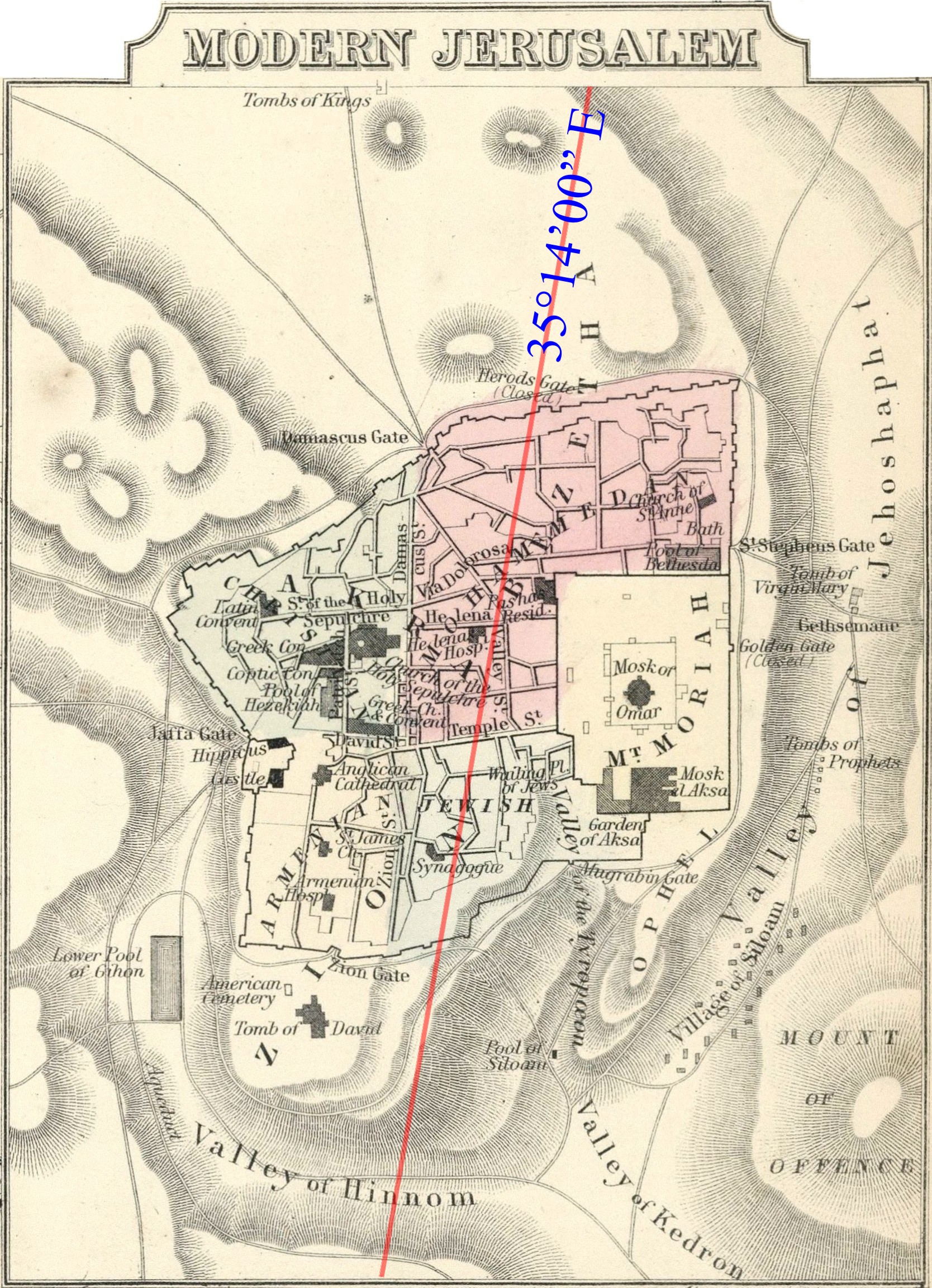
Figure 3. The Longitude of Old Jerusalem. The center of the Old City has a modern longitude of about 35°14’00” E. The meridian shown is not vertical because the original map was rotated relative to true north. (adapted from Mitchell 1865)
Figure 4 shows this same 35°14’00” E meridian plotted in the Midian region. It passes just west of the Jabal al Lawz range, whose main peak lies about 348 km (216 mi.) south of Jerusalem’s Mount Moriah. The longitude of this peak, 35°18’15” E (35.304°), is about 6.5 km (4 mi.) east of the Jerusalem meridian. Considering the relatively crude geography in Paul’s day, a position any closer to the Jerusalem meridian would seem more than eerie, if Jabal al-Lawz indeed represents the location of Paul’s Mount Sinai.
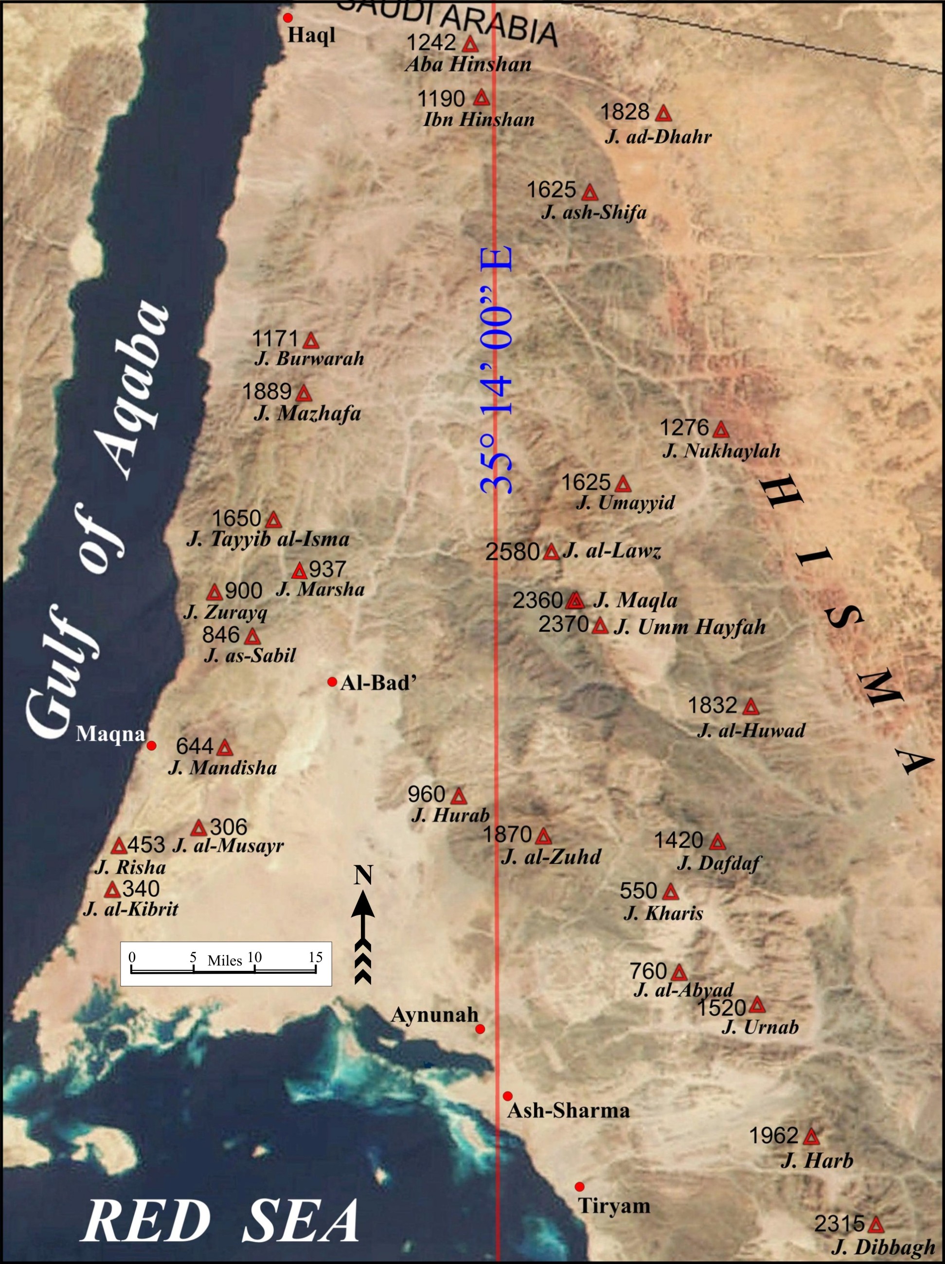
Figure 4. The Jerusalem Meridian within Midian. The 35°14’00” E meridian passes just west of the Jabal al-Lawz peak, which is located 348 km (216 mi.) south of Jerusalem.
A review of Ptolemy’s circa-AD-150 Geography shows that a fairly consistent system of longitude readings had been established over a wide region for many locations. Ptolemy’s longitudes started with 0° at the Canary Islands, the most western known point, and increased toward the east. Jerusalem, called Aelia Capitolia at the time, was given a longitude of 66° (Stevenson 1991, 128).
In the Midian region, Ptolemy listed the longitude of “Onne” as 66°20’ (ibid. 137). Onne refers to Aynunah. The modern longitude of Aynunah is similar to that of the Jabal al-Lawz peak, as shown in Table 1. The modern longitude of the Lawz peak, converted to Ptolemy’s coordinate system, is 66°01’, which is extremely close to the ancient 66° of Jerusalem.
Thus, secular data published within 100 years of Paul’s the letter to the Galatians confirms that specific knowledge existed concerning the meridian relationship between Jerusalem and a surmised Mount Sinai location near Midian.
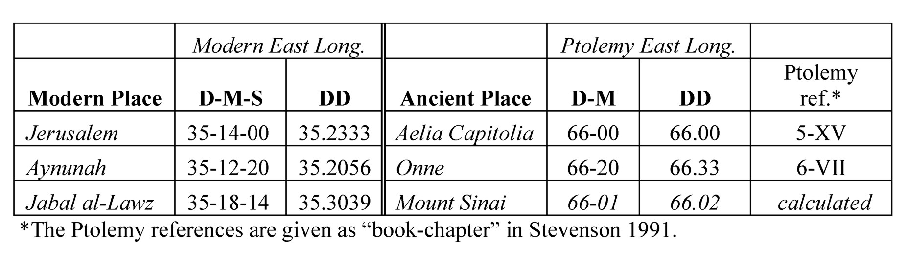
Table 1. Ancient and Modern Longitudes of Jerusalem and Jabal al-Lawz.
References
Burton, Richard F. 1979. The Gold Mines of Midian and the Ruined Midianite cities (1878). New York: Falcon-Oleander.
Gesenius, William. 1979. Gesenius’ Hebrew and Chaldee Lexicon, trans. Samuel P. Tregelles. Grand Rapids, MI: Baker Books.
Herodotus. 1980. Herodotus The Histories, transl. Aubrey de Selincourt. Great Britain: Penguin.
Josephus. 1960. Josephus Complete Works, trans. William Whiston. Grand Rapids, MI: Kregel Publications.
Kenneth A. Kitchen. 1994. Documentation for Ancient Arabia. Part I. Chronological Framework and Historical Sources. The World of Ancient Arabia Series, vol. 1. Liverpool: University of Liverpool Press.
Liddell, H. G., and Robert Scott. 1889. An Intermediate Greek-English Lexicon. Oxford: Oxford University Press.
Liddell and Scott. 2000. Greek-English Lexicon. Oxford: Oxford University Press.
Mitchell, Samuel August, Jr. 1865. A New Map of Palestine or the Holy Land. Philadelphia.
Stevenson, Edward Luther, trans. 1932. Geography of Claudius Ptolemy. New York: New York Public Library.
Strabo. 1966. The Geography of Strabo, trans. H. L. Jones. Cambridge, MA: Harvard Univ. Press.
Strong, James. 1990. The New Strong’s Exhaustive Concordance of the Bible. Nashville: Thomas Nelson Publishers.
Copyright 2003, 2016, and 2019 by Glen A. Fritz