Bible translations call the sea that was crossed in the Exodus the “Red Sea.” Tradition, going back to the 1st-century-AD historian Josephus, has relegated the crossing site to the northern part of the Gulf of Suez near Egypt (Figure 1 and Figure 3). But, the ancient idea of the Red Sea, shown in Figure 2, is too imprecise to pinpoint whether the Gulf of Suez or the Gulf of Aqaba was involved in the Exodus.
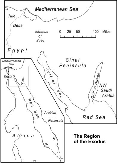
Figure 1. The Red Sea and its gulfs.
The identity of the sea crossed by the Hebrews is the most important piece of the geographical puzzle of the Exodus because it was a recurring landmark in the event, even being mentioned in the 40th, and final, year. This sea was also given as a landmark for the southern bound of the Promised Land in Exodus 23:31. This point would not be easily confused by the Hebrews who held that land as their heritage.
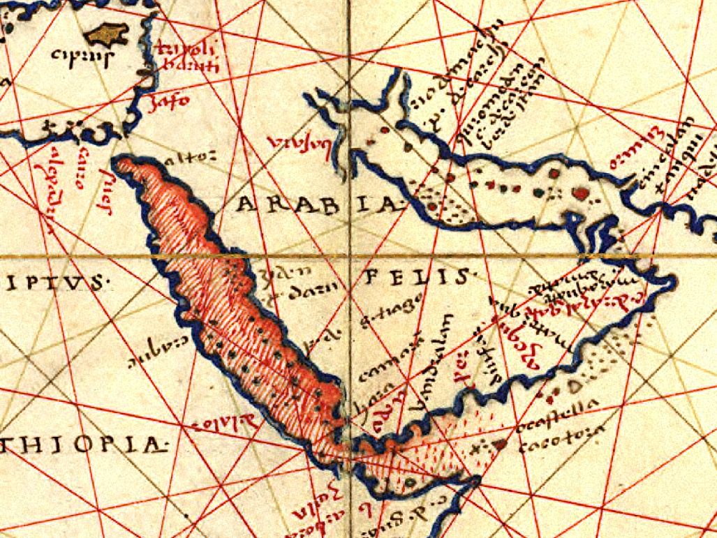
Figure 2. The Red Sea according to the chart of Agnese Battista (ca. 1544).
It is important to point out that “Red Sea” is not a translation of Yam Suph, which is the ancient Hebrew name for this sea. Red Sea was merely a geographical interpretation made by the Greek Septuagint scholars ca. 250 BC. Thus, the common use of Red Sea in English Bibles reflects a Greek custom that has nothing to do with the meaning or vocalization of the Hebrew Yam Suph. Yet, this traditional substitution has served to shroud the Yam Suph term in obscurity.
Over the last century, a number of scholars have proposed that Yam Suph was really the “Reed Sea,” and that it was located in some marsh lake on the eastern border of Egypt. However, the biblical geography evidence for this tradition is lacking. As a consequence of the uncertainty and confusion about Yam Suph, nearly every body of water surrounding the Sinai Peninsula has been proposed as a potential site of the sea crossing.
The Hebrew meaning of the Yam Suph term has also been a longstanding conundrum. Some scholars have scrutinized the term, hoping that its correct translation would yield geographical clues about its location. The popular idea found in many Bibles and encyclopedias is that Yam Suph means “Reed Sea.” However, close analysis reveals that “Reed Sea” is not a translation, rather, it is an interpretation that is encumbered with linguistic and geographical contradictions.
Biblically, there are at least a half dozen verses that specify a location for Yam Suph at the modern Gulf of Aqaba. Conversely, there is no single verse that specifies a location in the vicinity of Egypt. Nonetheless, the Gulf of Aqaba hypothesis has been scorned or ignored, mostly on the basis of the traditions that place Mount Sinai in the Sinai Peninsula and the sea crossing near Egypt. In addition, the Gulf of Aqaba is often dismissed as too far from Egypt to have been reached by the Hebrews in three weeks of travel, and too deep to have ever parted as the Bible described.
Most of these difficulties stem from preconceptions that are not based on the biblical account. The lack of an Exodus tradition for the Gulf of Aqaba is also raised as an objection. However, the lack of tradition is easily explained by its virtual absence from history and maps until the 19th century AD. A prime example is the 1544 representation of the Red Sea by Battista (Figure 1), which fails to portray the bifurcated head of the Red Sea that defines the modern Sinai Peninsula. This geographical ignorance can be traced to the longstanding reliance on the Classical Greek Geography, which omitted the Gulf of Aqaba. Its exploration and use was limited throughout history due to its navigation dangers, isolation, and lack of commercial utility.
In essence, Bible scholars did not associate Yam Suph with the Gulf of Aqaba because it was missing from their maps!
The Identity of Yam Suph
Biblical Parameters for the Location of Yam Suph
The biblical geography of Yam Suph makes its location coincident with the modern Gulf of Aqaba. Its biblical character (size and depth) would need to correspond with a large body of water such as this gulf.
Yam Suph appears in the Hebrew Scriptures 24 times, with 11 of these verses having spatial/geographical content. Seven of these verses link Yam Suph with the historical lands of Edom [6] or Canaan [7], which were directly north of the modern Gulf of Aqaba. This region is far removed from ancient Egypt. These seven Yam Suph verses are listed in Table 1. For demonstration purposes, the usual “Red Sea” term has been replaced with Yam Suph.
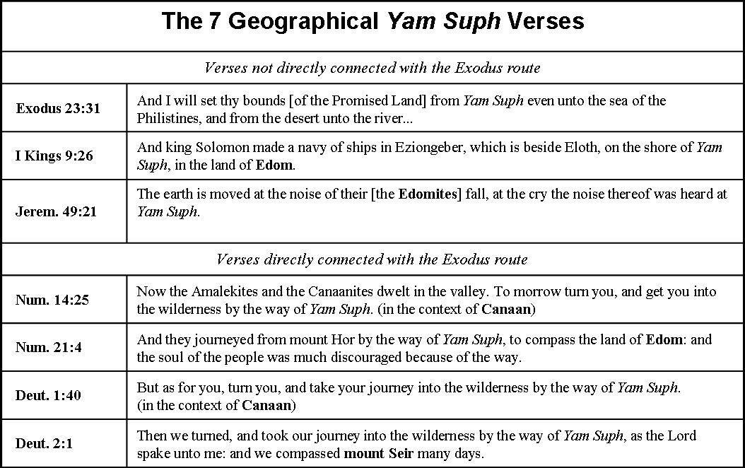
Table 1. The geographical Yam Suph verses linking it with Edom or Canaan.
Conversely, none of the 24 Yam Suph verses link it with Egypt. There are no verses that justify a Yam Suph location in the Isthmus of Suez or the Gulf of Suez; locations that are more than 150 miles west of the historic domains of Edom and Canaan. The Gulf of Suez, the northern terminus of the Septuagint Bible’s “Red Sea,” is only mentioned once in the Bible, hundreds of years after the Exodus, as the “tongue of the Egyptian sea” (Isaiah 11:15).
The most significant Yam Suph verse is Exodus 23:31, where the Lord, speaking to Moses, designated it as the southern landmark of the Promised Land. The importance of the land inheritance to the Hebrews makes it unlikely that they would misconstrue this boundary mark. On the whole, the Exodus 23:31 boundaries mirror those that were divinely given to Abram (Gen. 15:18), to Moses (Deut. 1:7 and 11:24), and to Joshua (Josh. 1:2-4). Four centuries after the Exodus, King Solomon built a navy at the head of Yam Suph at Edom (1 Kings 9:26).
It is noteworthy that the ca 250 BC Greek Septuagint Bible only assigned its “Red Sea” interpretation to 21 of the 24 Yam Suph occurrences in the Hebrew Bible. The three exceptions were verses in which Yam Suph was associated with Edom: Judg. 11:16, 1 Kings 9:26, and Jer. 49:21 (see Table 2).
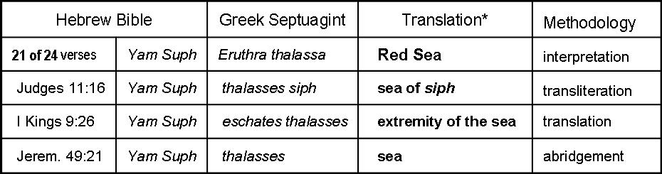
Table 2. Three Septuagint verses indicating that the scholars did not know what to call Yam Suph when it was mentioned in the vicinity of ancient Edom.
This circumstance implies that the Greek geographers of that era did not understand the size and position of the Gulf of Aqaba and did not have a name for it. To them, the Red Sea consisted of a single shaft of water ending near Egypt, without a bifurcated head as we now understand it. An example of this thinking is shown in Figure 3. This deficient geographical concept persisted until accurate mapping of the gulf was completed in the early 19th century.
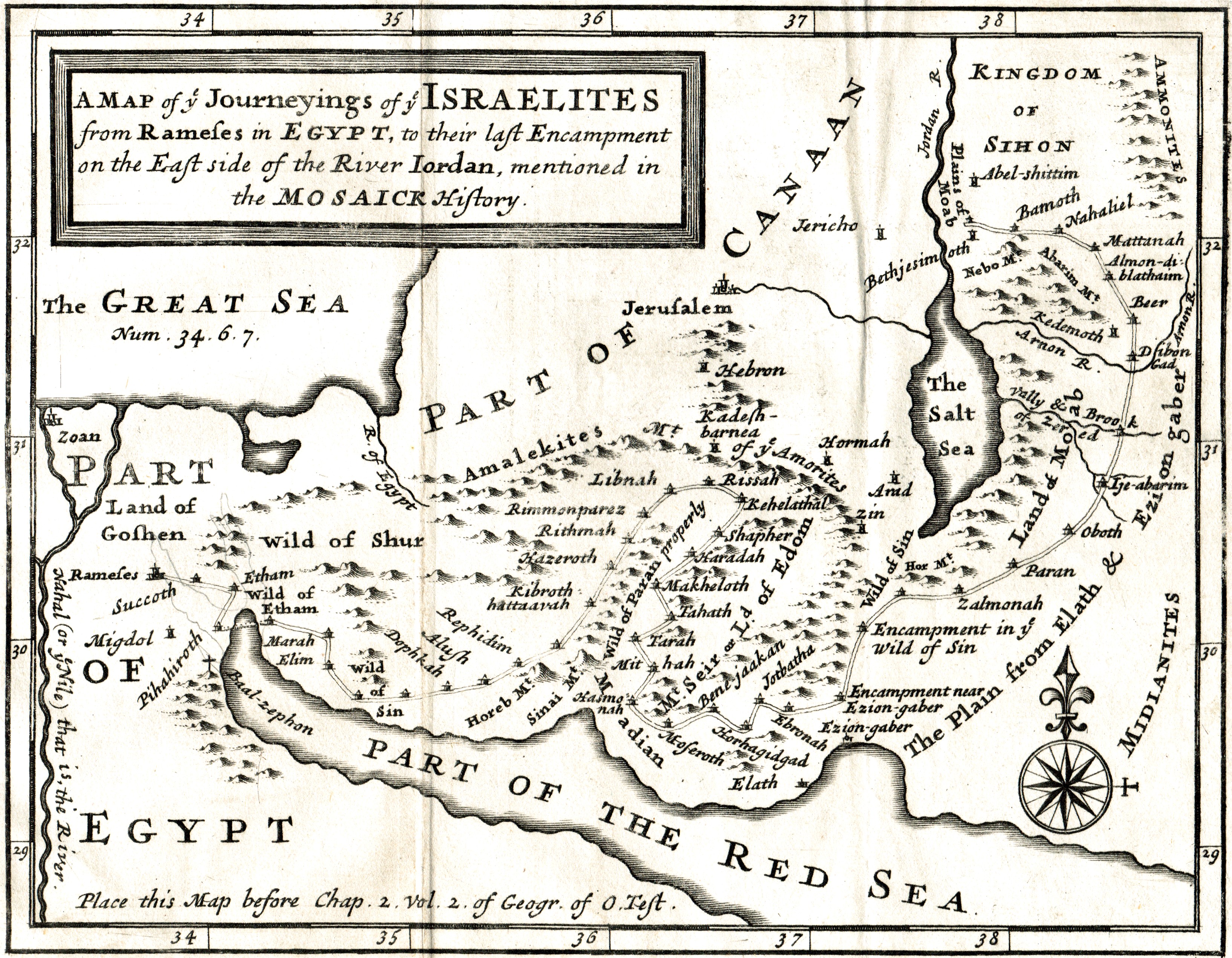
Figure 3. A 1711 map of the Red Sea (Edward Wells 1711) showing the great geographical ignorance of its configuration.
The Size of Yam Suph
The Exodus itinerary gives a hint about the dimension of Yam Suph. After passing through Yam Suph (Num. 33:8), the Hebrews spent three days in the wilderness of Shur. They then encamped at Marah, Elim, and then again at Yam Suph (Num. 33:9-10), before entering the wilderness of Sin (Num. 33:11) one month after leaving Egypt. These data suggest that the distance covered between the exit from the sea and the later encampment on its shore was a minimum of five travel days. The likely explanation is that the Hebrews were moving roughly parallel to a large body of water, such as the Gulf of Aqaba, rather than going in circles.
The Physical Character of Yam Suph
The Bible descriptors of Yam Suph (see Table 3) indicate that it was deep and mighty, with roaring waves. Such adjectives would apply to a sea like the Gulf of Aqaba, but not to the various inland Yam Suph venues that have been postulated near Egypt.
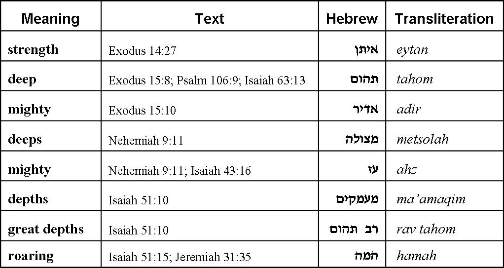
Table 3. Biblical descriptors of Yam Suph.
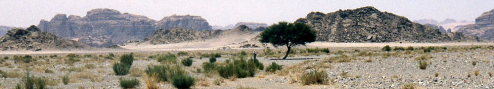
Topographically, the modern Gulf of Aqaba has limited access to its western shore from the interior of the Sinai Peninsula, and limited space along its shore to host a large multitude. The one exception is found near the midpoint of the gulf at the town of Nuweiba, where the outflow of the Wadi Watir has produced a large, sandy beach head, shown in Figure 4.
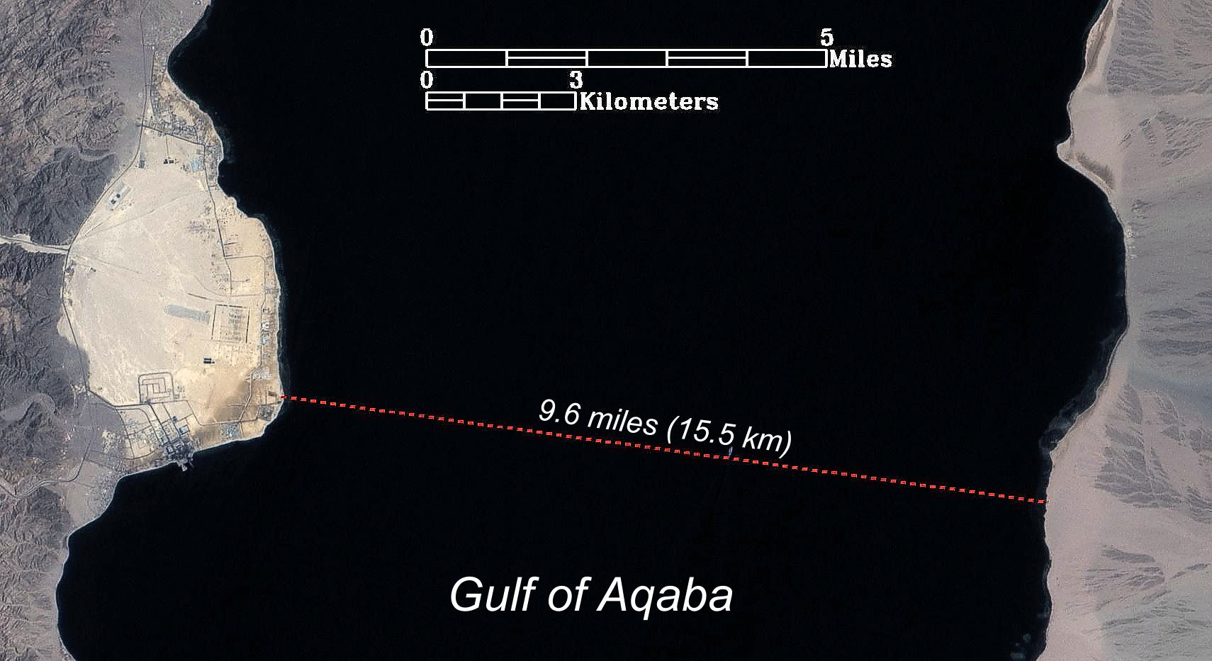
Figure 4. The Nuweiba beachhead (left) in the mid-Gulf of Aqaba.
The shore opposite Nuweiba is comprised of a large beach that hosts one of the few accessible routes leading to the interior of what was ancient Midian. The intervening seafloor is the only section of this gulf that does not present the steep inclines, drop offs, and obstructing reefs that are typical of the gulf. Despite the gentle seafloor terrain, the depths at the midpoint of this section of the gulf approach 850 meters (2,600’+) (Hall 2000). It is very deep and there is no natural explanation for a sea parting in this locale.
Conclusion
The biblical descriptions of the character and location of Yam Suph only correlate with the modern Gulf of Aqaba. The traditions for a sea crossing near Egypt gained their strong foothold because the existence and nature of this gulf were unknown for most of history. By default, it was the Lost Sea of the Exodus!