The location of Mount Sinai was clearly explained in the 4th century AD by Christian scholar, Eusebius of Caesarea (AD 260/265-339/340) and reiterated by theologian Saint Jerome (ca. AD 347-420) (Eusebius et al. 2003). In modern terms, they placed it east of the Gulf of Aqaba in northwest Saudi Arabia, in the vicinity of ancient Midian. Eusebius recorded that Madiam (Midian)–
…is a city… [that] lies beyond Arabia to the south in the desert of the Saracens, east of the Red sea. From this they are called Madianites, and it is now called Madian (ibid. 70).
He went on to define Horeb as–
the mountain of God in the land of Madiam. It lies beside Mount Sinai beyond Arabia in the Desert (ibid. 95).
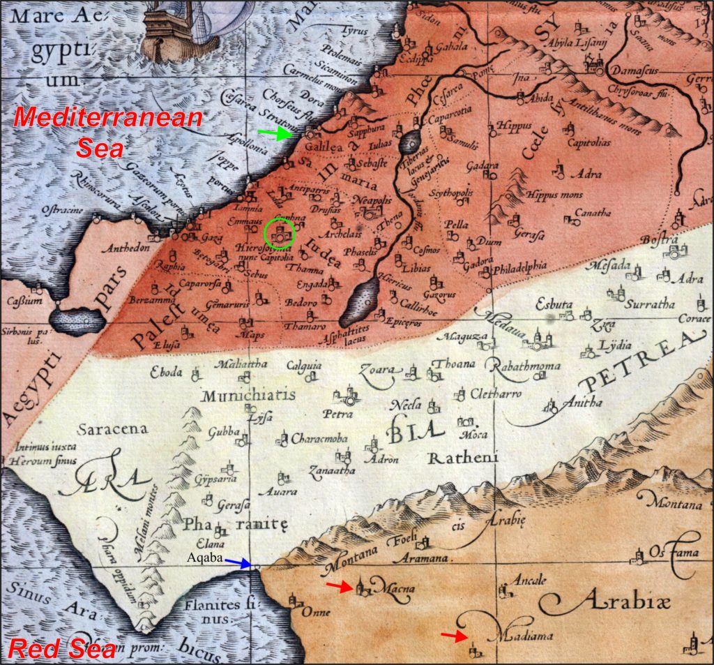
Unfortunately, these descriptions have generally been misunderstood or ignored due to confusion about the “Arabia” term. However, Eusebius’ definition of “Arabia” is easily explained using the Renaissance-era map in Figure 1. It is based on the ca. 150 AD work of the Greek Geographer Ptolemy, who compiled the geographical knowledge of the 2nd-century AD Roman Empire.
Looking at the map, Eusebius lived on the Mediterranean coast in Caesarea (green arrow), in Palestine (red-brown area). Jerusalem is circled (green). The white area below Palestine is “Arabia Petraea.” The brown area below Arabia Petraea is “Arabia Felix.” Ptolemy defined Arabia Felix as lying east of the modern Gulf of Aqaba, south of its terminus at Elath (Elana, Aqaba):
[It is] terminated on the north by the designated border of Arabia Petraea… [and begins] from the terminus of the Arabian gulf near the Elanite bay (Stevenson 1932, 137).
The “Elanites Sinus” in Figure 1 is a distorted Gulf of Aqaba with its head or terminus is at “Elana” (blue arrow). The white area of Arabia Petraea ends at this point. The locale of Midian within Arabia Felix can be inferred from the Ptolemaic towns of Macna and Madiama (red arrows) which correspond with the historic Midian towns of Maqna and Al-bad’, the latter being the Madyan of the medieval Arab geographers. Midian was also placed in Arabia Felix by the 1st-century AD Jewish historian Josephus (AD 37-ca. 100) (cf. Ant. I.xv.1 and Ant. II.xi.2).
Hence, the “Arabia” of Eusebius’ is logically Arabia Petraea, if Midian was located “…beyond Arabia to the south in the desert of the Saracens, east of the Red sea” (Eusebius et al. 2003, 70). More specifically, it could have been the Roman Provincia Arabia portion of Arabia Petraea, which was created when the Romans annexed the Nabataean kingdom in AD 106 as a frontier province (Bowersock 1971 & 1983).
What about “the desert of the Saracens”? The southeastern frontier of Provincia Arabia was guarded by the Roman line of fortifications called the Limes Arabicus. The purpose of the Limes “was to control the movements and raids of nomadic Arab tribes migrating northwest from the Arabian Peninsula into the Empire” (Parker 1982, 1). These peoples were frequently referred to as “Saracens” (Retso 2005).
Returning to Eusebius’ definition of Horeb as:
the mountain of God in the land of Madiam. It lies beside Mount Sinai beyond Arabia in the Desert (Eusebius et al. 2003, 95)
it can be stated that Mount Sinai was in or near Midian. In Eusebius’ Greek manuscript, Horeb was described as being in the “outlying countryside [Greek: chora] of Madiam…” (Kerkeslager 1998, 197). “Eusebius’s use of chora, a word that sometimes refers to the outlying countryside dominated by a city, suggests that he believed that Mt. Horeb was in the immediate environs of Madiam.” (ibid.)
Two other historians gave useful specifics about Mount Sinai, Philo (ca 20 BC- AD 40) and Josephus (ca AD 37-100). Philo (in Moses II.xiv.70) described the mountain of God as “the loftiest and most sacred mountain in that district…a mountain which was very difficult of access and very hard to ascend.”
Josephus said that “the mountain called Sinai…[was] the highest of all the mountains thereabout, and the best for pasturage, the herbage being good there; and it had not been fed on upon, because of the opinion men had that God dwelt there, the shepherds not daring to ascend up to it…” (1960, Ant. II.xii.1). Josephus later reiterated: “…mount Sinai…is the highest of all the mountains that are in that country” (ibid. III.v.1).
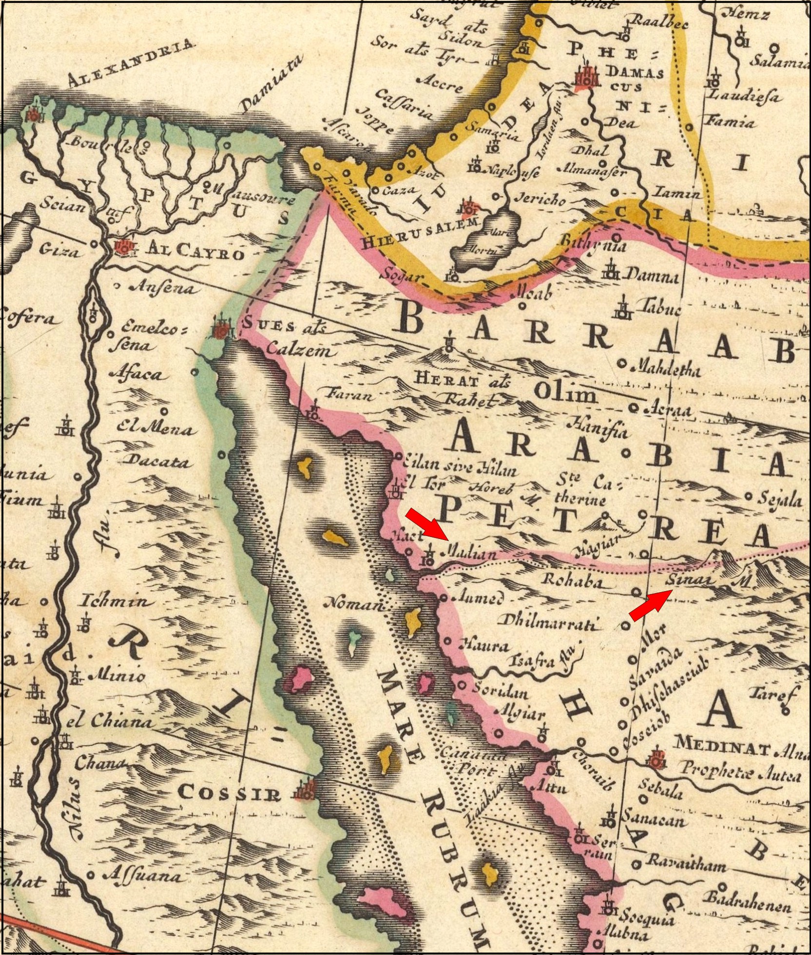
If we are looking for the tallest mountain in the Midian region. it is easy to point out the Jabal al-Lawz range, which has the tallest peak in northwest Arabia at 8465 feet (2580 m). The antique map in Figure 2 displays just such a location for Mount Sinai relative to Midian (red arrows). The map was drawn before the position of the modern Gulf of Aqaba was understood.
NOTES:
A careful reading of the Hebrew biblical text shows that Horeb was not a mountain per se, but rather the region in which Mount Sinai was located. In other words, Sinai was a mountain in Horeb.
REFERENCES:
Bowersock, G.W. 1971. A Report on Arabia Provincia. The Journal of Roman Studies 61: 219-242.
______. 1983. Roman Arabia. Cambridge, MA: Harvard University Press.
Eusebius, of Caesarea; Jerome, Saint; G S P Freeman-Grenville, Rupert L Chapman, Joan E Taylor. 2003. The Onomasticon: Palestine in the Fourth Century A.D. Jerusalem: Carta.
Josephus, Flavius. 1960. Josephus Complete Works, trans. William Whiston. Grand Rapids, MI: Kregel.
Kerkeslager, Allen. 1998. Jewish Pilgrimage and Jewish Identity in Hellenistic and Early Roman Egypt. In Pilgrimage and Holy Space in Late Antique Egypt, ed. David Frankfurter, 99-225. Boston: Brill.
Parker, Thomas S. 1976. Archaeological Survey of the Limes Arabicus: A Preliminary Report. Annual of the Department of Antiquities of Jordan 21:19-31.
______. 1982. Preliminary report on the 1980 Season of the Central Limes Arabicus Project. Bulletin of the American Schools of Oriental Research 247: 1-26
Retso, Jan. 2005. The Arabs in Antiquity: Their History from the Assyrians to the Umayyads. New York: Routledge-Curzon.
Visscher, Nicolaes. 1690. Nova Persiae, Armeniae, Natoliae, et Arabiae
Stevenson, Edward Luther, trans., ed. 1932. Claudius Ptolemy The Geography. New York: New York Public Library.


